Current research projects
PEP-BIOccIA: mapping natural environments and predicting species presence using AI and modeling
The PEP-BIOccIA project (2024-2026) aims to improve medium and long term biodiversity conservation planning in the Occitanie region. It will lead to the creation of a software tool that provides access to updated maps of natural environments each year and allows for the prediction of species distribution across the entire regional territory, both today and projected for 2050.
Psi-Biom: biodiversity management platform integrating theInternet of things, AI, and modeling

The Psi-Biom project (2022-2024) aims to provide a comprehensive data processing chain for biodiversity management. It leverages the integration of the Internet of Things (IoT sensors), artificial intelligence (automated species recognition algorithms), and modeling of ecological dynamics within a single platform for the development of digital twins.
Forbes: supporting the financing of sustainable infrastructure and non-financial reporting by companies

The Forbes project (2025-2030) is designed to create tools that will guide local authorities in their strategy for financing biodiversity-friendly infrastructure, as well as assist businesses in evaluating and reporting (CSRD) their contribution to the preservation of species and ecosystems.
Polymor-FENCE: AI and Modeling for Analyzing the Ecological Impacts of Fencing
Fences act as obstacles for wildlife. The Polymor-FENCE project (2024-2026) aims to study their direct effects (animal mortality) and indirect effects (fragmentation of natural habitats). It specifically focuses on the fences of photovoltaic power plants within the context of the massive development of these installations, ensuring that decarbonization and biodiversity conservation can be pursued in tandem.
OptiBioNum: integration of ecological indicators into BIM tools to optimize the design of structures

The OptiBioNum project (2025) aims to guide building and infrastructure designers in optimizing the capacity of their structures to support biodiversity. It is based on the creation of standardized ecological indicators and their integration into 3D digital modeling tools (BIM and GIS). This allows for detailed evaluation of design scenarios from the early stages of a project.
Completed research projects
AIGLE : identifying bird species of metropolitan France to better prevent collisions
SimOïko: the biodiversity simulation software
SimOïko is a modeling tool for the life of species in their natural environment. It is derived from the transfer work of the ecological model MetaConnect, developed as part of Sylvain Moulherat's doctoral thesis (co-founder of TerrOïko) and owned by the Station of Theoretical and Experimental Ecology of the CNRS. SimOïko is designed to assist biodiversity professionals in their analyses, diagnostics, and studies, while also informing management and conservation decisions regarding species.
Cirfe: comparative study of ecological modeling methods applied to transport infrastructure
The Cirfe project (2015-2017) aimed to test various modeling tools proposed by scientific research in ecology and compare their predictive capabilities. This work was conducted under real conditions as part of the evaluation of the cumulative effects of linear terrestrial transport infrastructure.
ConAquat: assessing and compensating for impacts on biodiversity in aquatic environments
The general aim of the ConAquat project is to develop a tool that can be transferred to the operational environment, for use by government departments, design offices and public and private developers, to quantify and spatialize biodiversity losses and gains linked to the impact of development projects and plans on aquatic environments (rivers, lagoons and coastal estuaries).
Ocapi: the AI-assisted data analysis software for camera sensors
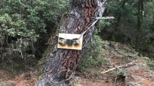
The Ocapi project (2020-2021) led to the development of a tool for the automatic recognition of animal species in images, supported by artificial intelligence. It was initiated in a context characterized by the increasing acquisition of field data through the deployment of sensors (camera traps). The automated analysis of this data aims to improve collision risk management and monitor the effectiveness of environmental measures along transport infrastructure.
MINnD: BIM for infrastructure
TerrOïko, a member of Cinov, has been commissioned to participate in the collaborative research activities of the MINnD program (Modeling of Interoperable Information for Sustainable Infrastructures). The goal of this national program initiated in 2014 is to identify the needs for 3D models of the digital mock-up of transport infrastructures. TerrOïko is involved in use case number 6 ("Infrastructure and Environment").
Bison: building the Europeanroadmap for biodiversity-friendly transport infrastructure
The Bison project (2021-2023) aimed to identify ways to reconcile nature conservation with the development of transport infrastructure in Europe. Funded by the EU under the Horizon 2020 program, it brought together 44 partners from 16 countries. TerrOïko was one of the main contributors in France.
BioBIM: integrating biodiversity into BIM infrastructure
The BioBIM project (2018-2019) aimed to explore the possibilities of integrating digital environmental management technologies into building and infrastructure modeling tools, and to raise awareness of these opportunities among developers and managers of transport infrastructure.
MetAqua: extending simulation to terrestrial aquatic environments
The MetAqua project (2017-2018), carried out in collaboration with SETE-CNRS, aimed to test the predictive capabilities of SimOïko for pelagic species and, if necessary, to develop simulation algorithms tailored to these species.
Tram-MidPyr: modeling ecological functions applied to green and blue networks
The Tram-MidPyr project (2014-2015) aimed to develop tools for analyzing and assessing the territorial network of Green and Blue Infrastructure for urban planning documents in the Midi-Pyrénées region.
Our publications
Read our latest scientific and technical articles on digital technologies and biodiversity.
