Definition of the black betwork for the eurometropolis of Metz, action program, and recommendation guide
Simulation (SimOïko)
Data processing
Eurometropolis of MetzInstitutional actor
December 2021
Jérémie Cornuau
The context
The concept of "dark network" aims to integrate the impact of light pollution on biodiversity into territorial planning. It seeks to protect ecological networks that are minimally impacted and to restore those most affected by fragmentation caused by artificial light.
The client
The territory of the Metz Metropolis covers 44 municipalities and an area of 306 km².Illustration principale

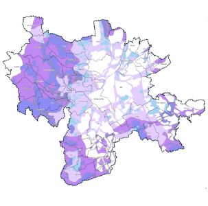
Interpreted map of the dark network
The mission
The study consisted of:- mapping light pollution across the territory of the metropolis.
- diagnosing its impact on species using our population dynamics simulator, SimOïko.
- spatializing the dark network.
- defining a strategy to mitigate the impacts of light.
- implementing communication and awareness-raising actions.
Customer needs
Facilitate the project process
Ensuring consultation around the project
Design appropriate management measures
Develop an action plan
Plan
Prioritize interventions
Propose actions
Awareness raising
DATA NEEDED
FOR THE STUDY
- Light pollution mapping
- Habitat description (under GIS)
- Available open data (IGN, Corine...)
- Scientific literature and expert opinions
METHODOLOGIES
USED
- Statistical data analysis
- Communication
- Territorial consultation
- Collection of expert opinion
- Review of scientific literature
- Fauna-flora simulation
- GIS data analysis and processing
- Viewing results